In a little over ten years, South Africa based airborne geophysical company, Xcalibur Airborne Geophysics has successfully collected over three million line kilometres of low level data for its client base of major mining companies and junior exploration businesses. Specialising in ultra-high resolution and standard airborne surveys, utilising gradient magnetics and radiometrics, time-domain electromagnetics and gravimetry, Xcaliber’s fleet of robust turbine Air Tractors, BN-2T turbine Islanders, Jet Rangers and Eurocopters have since been operational throughout the African continent.
“Since its formation in 2002,” explains Chief Geophysicist, Tiaan Le Roux, “the company has grown from a small team of about four or five people to one that today employs just under 20 individuals, including geophysicists, data processors, engineers, pilots, field operators, and support personnel.”
Originally founded by Billy Steenkamp, Xcalibur today possesses a team who collectively offer more than 100 years of managerial and practical experience in fields including exploration geophysics, aviation, business management, electronic engineering, and airborne survey operations. The company’s pilots are some of the most experienced in their field, amassing thousands of flying hours between them.
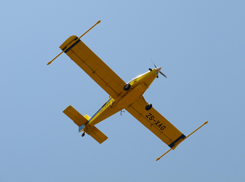
The aforementioned fleet of aircraft at these pilots' disposal are unique in that they enable Xcalibur to collect data at the lowest ground clearance that is possible within operational safety constraints, typically between 20 and 40 metres. Flying at such altitudes provides for better spatial resolution and data signal-to-noise ratios, thus resulting in significantly more detailed information for kimberlite detection, base and precious metal exploration, litho-structural mapping and environmental or mine planning applications.
“We recognise the fact that we are very much a company delivering a niche service, and what we take great pride in is delivering excellent quality products in the most cost efficient way possible,” Le Roux continues. “The technologies that we employ are among the most advanced and modern of their kind and are mounted on airborne platforms that are really robust and conditioned for use in Africa. These aircraft are characterised by their endurance and low maintenance costs, which helps drive our costs down. Ultimately we pass these savings onto our clients together with quality data.”
The airborne platforms that Le Roux speaks of are equipped with state of the art navigational, positioning and geophysical equipment. The Differential Global Positioning System (DGPS) allows for accurate positioning of better than one metre, while the navigational system allows for accurate dynamic navigation along pre-determined flight paths, which will ensure that data quality is maintained. High sensitivity wingtip mounted or boom mounted magnetometer sensors and state of the art multi-crystal pack spectrometers are used to measure exceptionally small variations in horizontal magnetic gradients and natural radioactive emissions.
Xcalibur’s geophysical services, individually trademarked as the Xtract, the Xgrad and the Xgrav Systems, are further boosted by the company’s value add data processing and interpretation Xval service. “This particular service aims to offer our clients a more complete package of services,” Le Roux states. “Rather than simply acquiring the data and passing it back to our clients, our own extensive geophysical and geological experience means we can offer consultancy services that cover a wide range of methodologies and applications with the view to properly integrate the information we collect with other geoscientific data.”
Xcalibur’s technology and efficient services have consistently produced first class results time and again. It is this level of consistency that has seen the company being awarded numerous projects by a wide range of major mining and exploration companies, junior and government organisations. Such projects have allowed Xcalibur to prosper where others have struggled during the recent difficult times for the mining community.
In the coming months Xcalibur will be moving forward with the introduction of its newest solution, the XtractEM System. “There is a strong demand in the market today for combined high resolution magnetics and electromagnetics,” Le Roux says. “The reason for this is that some of the targets of our airborne applications only have very subtle magnetic signatures. By acquiring electromagnetic data, in addition to magnetics and radiometrics, one can often not only confirm these targets, but also better delineate and characterise them, which gives clients the confidence needed to follow up and drill these prospects.”
While completing and testing the new XtractEM System, Xcalibur will continue to build upon its growing reputation for delivering first class results and services to its clients.
Written by Will Daynes, research by James Boyle
 Xcalibur-Africa-Mining-Feb14-Bro-s.pdf