Mining appears straightforward, but success depends on a host of different activities and disciplines, making it difficult to predict future performance and easy to hide uncomfortable facts. MICROMINE produces a software suite that draws an accurate picture to support sustainable business and sound investment decisions.
Question: wherein does a mine project’s value lie? Answer: the quality of its resources and the effectiveness of the plan for exploiting these. Well, that is part of the answer. Further down the line the many thousands of active mining projects depend on their ability to attract investors on the world’s stock exchanges and venture markets. At the one end there is the mass of data generated by historic explorations, current and recent drilling programs and the researches of geologists; at the other there are individual institutions and governments keen to push forward but wondering which projects are going to fly and which may crash. How can they know?
So many questions, and who can blame the major and minor players for talking up the projects on which they have hung their hats? Investors rely on analysts, though, to make sense of the data put out by the mining companies. That is where MICROMINE comes in. The company had its origins on a boat gathering ocean floor data in Australian waters for an oil and gas (O&G) company. At the time, 1986, the data had to be faxed onshore. The three mining surveyors on the boat, including managing director Graeme Tuder, knew there had to be a better way so they pooled their expertise, developed the 3D modelling program that is now Micromine and incorporated the company in that hottest of mining hotspots, Perth.
From there the company spread throughout Australia, where its products are to be found in the vast majority of mines, from the coalfields of the Hunter Valley and Bowen Basin to the open pit iron ore mines in the Pilbara – and every type of smaller project, too. Now it is true to say it is present in every mining hotspot in the world from Russia, China and South Africa to the Americas, with two offices in the US and a major presence in Vancouver, Canada. That growth came not from business development but through consulting. “Micromine Consulting Services delivers competent person reports compliant with international and local reporting standards such asJORC, NI43-101, SAMREC, SEHK (Chapter 18, Hong Kong), China MLR, Mongolian Standard, GKZ Standard and PERC Code,” says Rhonda Bulmer, sales manager for North America. “Often it came out of Pitram and Micromine Consulting because we dominate underground mining as a product of choice globally.”
The defining factor and the unique proposition of MICROMINE is that unlike most of its competitors, MICROMINE’s products weren’t adapted from existing IT platforms – every one of its offerings from the original exploration and mine design product Micromine to Geobank, the data management system and the operations management tool Pitram was designed from the bottom up by miners and mining geologists. Bulmer thinks this has a lot to do with the global success MICROMINE has had. “Both the methodology and the terminology are familiar to mining professionals – they are comfortable with it.” Even Geobank, which was acquired from BHP Billiton in 2000, has the same pedigree; it was created by geologists for geologists. “It is a logical geological database!” she explains epigrammatically, “which means it naturally takes the user on the journey that a professional geologist would need to go on.”
Rhonda Bulmer came to MICROMINE in 2009 attracted by the opportunity to exercise her enthusiasm for business information modelling – she describes herself as a BIM evangelist – in a company that really buys into that concept and whose tools are tailor made for clients who see BIM as the future of mining design and implementation. “BIM works for any process that has a design attached – from underground resource design right through to above ground infrastructure design. It does two things; it gives a visual single model by uniting a multiplicity of design inputs to a project, reducing error and making best use of time, and it introduces intelligent processes.”
The bugbear of mining, and construction too for that matter, has always been that the most pertinent questions were never asked until too late in the process, resulting in extensions, variations and reworking, she continues. “BIM brings critical issues to the beginning so you can eradicate them or at least reduce them; and we all stay honest round the table so that we all know what is going on: that is what I am promoting, and that is why I joined the mining industry!”
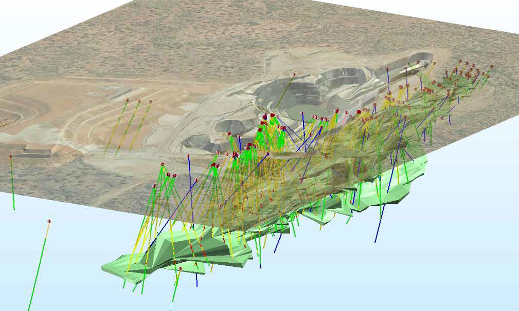
Her terminology is revealing – she uses the words honest and truth a lot and sees the MICROMINE proposition as offering that source of truth right through the process from data management to funding decisions. Take Geobank. Data is a minefield in more ways than one! A mining company inherits tranches of historical data then adds to it by running its own drilling programme: then it has to make sense of these disparate blocks of information. “Geobank is like the machines that sort out different notes in a bank – it lines up the data so you can count it more easily.” The biggest competitor, she says, is the familiar Excel spreadsheet, but apart from its catch-all design (and the fact that it comes at no more than the cost of an MS Office licence) it is not as infallible as its proponents suggest. MICROMINE ran one client’s data through Geobank and discovered not the handful of errors expected but 40,000 of them, including intervals missing, duplications, and big holes in the data. “Geobank picks all that up so when the time comes to visualise the model, you have a very accurate picture to report back to the public and the shareholders.”
So even if a company outsources its data management – perhaps especially so – it is worth its while to install Geobank to be able to present clean data to the analyst. It keeps them honest. And Geobank is the most cost effective solution around. The nearest data extraction competitor charges up to $60,000 to implement, which is four times dearer than Geobank – and Geobank like its sister products is modular and can be customised to the client, unlike the competing ‘fixed databases’ where what you see is what you get. “What we really hang our hat on,” asserts Bulmer, “is that we work first with the exploration company, then the geologist and the exploration manager to grow with that business. Early stage companies haven’t got a lot of money but they need to codify their asset because that’s what will get them the money!”
Having conquered Australia where MICROMINE products are widely used to support target generation through to mine operation and it is now a partner in the ACARP Project, an initiative by the Australian Coal Industry to establish a Borehole Data Logging Standard, the company has established an unassailable lead in many vital markets such as South Africa and Indonesia. In China and Mongolia, when mining companies submit resource documentation or reports on drilling campaigns, they are required by the government to supply it in a Micromine file generated by the Micromine 3D product – a truly breathtaking achievement.
Now Canada is seen as wide open simply because of the rate of growth of mining there. There are estimated to be more than 2,000 exploration companies actively working within Canada alone and these are the companies MICROMINE is keen to work with. “Canada is the biggest mining growth area in the world. We understand that there is a distrust of software companies among the mining community – they have seen them as predatory and a lot less interested in supporting their products than they are to sell them.” MICROMINE’s strategy will be to make itself known in the first place by taking roadshows to the main mining cities, running seminars and workshops and making a big splash at all the industry exhibitions.
Another product that will appeal in Canada is Field Marshal which backs up Geobank, exists on a handheld and collects in-field data. For people who are used to coming in from a day’s logging on paper, cross-eyed and only too aware of the errors that are bound to creep in, Field Marshal is the ideal way to capture data accurately and then upload it to the parent database. It is cheap, and once bought it is the property of the client – no need to buy an annual licence.
The sales team has already been doubled and will double again, she says – expect to see another office opening in the east. In particular, she intends to deliver an exemplary level of ongoing support to customers old and new in Canada, walking every step of the way with them. “If we just came in as a one hit wonder we could expect a lot of single sales but not a viral take-up, because people would not know how to make it work for them. We are prepared to invest a lot of time and add a lot of value to get our customers up to speed.” But new users invariably comment not only on the logicality of the programme from an industry point of view but on how user-friendly it is, she says. “The Windows interface is familiar to everyone, and there are wizards to take you through different tasks so you don’t have to rely on your memory of the training you did six months ago!”
Even upgrades and new releases, a constant headache for subscribers to the major platforms and often seen as a big hidden cost, are just another service in MICROMINE’s world, included in the annual licence fee. “Prior to the release we run half day workshops and seminars in the evening to familiarise users and to help them understand how it might affect their workflow. We will also run transition workshops and go to the clients and talk them through these changes.”
In any case, like the core product, changes are mainly user generated, Bulmer adds. The most recent release of Micromine has an entire segment around Google Earth. “People wanted to be able to put a plan view directly into Google Earth and see what it looked like – did it butt up against the forestry restrictions or the cultural buffer that has been put on the property, for example?” In one case this revealed a geo-referencing error that would have crossed a watercourse – a good example of how Micromine is an open model and a two way street, she points out.
Written by John O’Hanlon; research by Richard Halfhide
DOWNLOAD
 Micromine-AM-Sept12-Bro-s.pdf